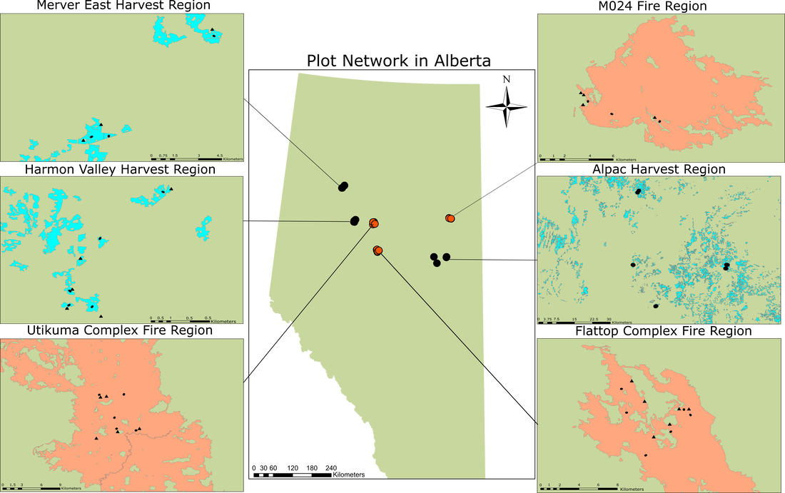
Figure 5. Plot network within Alberta. Red points represent fire plots, black points represent harvest points. Within the insets, circles represent islands, and triangles represent reference sites.

Figure 6. Plot layout within a site. The island is shaded in red, and the white circles represent plots (circles not to scale).
|
To start, we decided to select sites in the boreal forest that had been disturbed approximately a decade before sampling. We picked a decade because we wanted to wait a long time after disturbance to allow edge effects to set in. We couldn’t select an earlier time period because the practice of patch retention harvesting wasn't commonplace in Alberta before 2010, which would have severely reduced our harvest site options. We identified three harvest areas that contained retention patches (Alpac, Mercer East, and Harmon Valley). Three fires (Flattop complex (2011), Utikuma complex (2011), and M024 (2009)) were identified as candidate fires (Figure 5). Each fire/harvest region contained 3-7 remnants, for a total of 15 harvest and 15 fire island remnants which were between 0.65-2.7 hectares in size. Furthermore, we located all of our sites within deciduous dominated forest, with a medium nutrient regime and mesic soil moisture. Each island remnant was paired with a nearby section of continuous undisturbed reference forest that bordered the same disturbance (Figure 6). Within each reference-island pair we had 4 circular plots with a radius of 11.3m: island interior, island edge, reference edge, reference interior (Figure 6).
|
|
Plots were placed next to each other to simulate a transect but were moved if they would be placed in an area that was not representative of the forest around it. For example, if the plot fell within a wet area with wetland vegetation, the plot was shifted perpendicularly to the transect until it was completely within forest vegetation.
Within each plot, general tree attributes such as Diameter at Breast Height (DBH), species, and status (alive or dead) were recorded, as well as sapling counts and microclimate in the form of air and soil temperature. The volume of dead standing trees and fallen dead trees was recorded, and each tree was assigned a decay class value between 1-5, with 1 being least decayed, and 5 being most. Trees of decay class 1 & 2 were called recent deadwood and were assumed to have died within the past 10 years. Microclimate measuring was done using the Tomst TMS-4 dataloggers (Wild et al., 2019). Each plot also contained three subplots in which percent covers of understory plant species were recorded (Figure 7). Trees less than 1.3m tall were considered as part of the understory. Within each sublot, canopy cover was measured by spherical densiometer at four cardinal points, and then averaged. |

Figure 7. An example of a 0.5m radius subplot
|

Table 1. Table showing number of plots sampled.
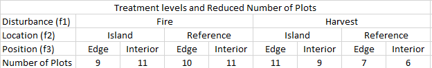
Table 2. Table showing number of plots reduced based on explanatory variables.
|
After fieldwork was completed, we critically examined the references and islands we had sampled and decided to drop some sites that didn’t meet our filtering criteria. Some examples of stricter filtering criteria include references that were too small or had been disturbed too recently, as well as islands that were too large, or bordered disturbances such as roads. This resulted in a plot layout detailed in table 1. Next, we lost some data due to animals removing our microclimate sensors, thus any analysis that uses explanatory data is done using a subset of the data described above. This subseted plot layout is presented in table 2.
|
